| Take Off: | P5 18:17 UTC | P6 18:10 UTC |
| Touch Down: | P5 21:14 UTC | P6 21:03 UTC |
| Duration | P5 2:57 h | P6 2:53 h |
The major technical objective of the flight was to train the in-flight coordination between P5 and P6,
including the lidar operation and the drop sonde release. From a science point of view the mission aimed
at collocated radiation and remote sensing measurements above a layer cloud by P5, with concurrent cloud sampling by P6.
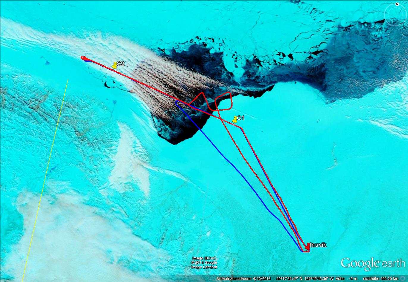
We were headed out of Inuvik to waypoint 1 (C1) above sea. On the way to C1 the P5 aircraft adjusted vertically with P6,
whereby P6 went first with about two minutes lead time. Before reaching C1 the lidar was switched on. From C1 on both
aircraft measured in close collocation until C2 which was extended until the US borderline during the flight.
Cloud conditions continuously improved between C1 and C2. At the beginning of the track there were no clouds at all.
After the first third of the way between C1 and C2, clouds were shallow, getting thicker towards C2. After reaching C2
we returned into the direction back to C3 whereby we changed the order of the aircraft. P6 went first (lower level,
penetrating clouds) with P5 following two minutes after P6 above clouds, again in close collocation. We released two
drop sondes on our way from C2 to C3. After reaching C3, P5 separated from P6, and P5 flew a horizontal (at 10,000 feet altitude)
square pattern to check the upward-looking radiation sensors. Then the lidar was switched off and P5 returned to Inuvik.
All instruments seemed to work properly, except the horizontal stabilization for the downward looking radiometer which was fixed during the whole flight.
Between C1 and C2 Polar 6 penetrated some patchy clouds. Not stratus, more cumulus humilis and mediocris with thicknesses between 300 and 400 ft.
Later clouds turn into thicker stratus deck with clear sky openings. We fly in a ''chasing mode'', i.e. along the planned flight track albeit
with altitude varying such that we spend as much as possible time inside clouds.
When arriving at the turning point past C2,
the Polar 6 turns towards Point C1. We drop down below the cloud deck and start a ''staircase experiment''.
For this the vertical and horizontal dimensions of the cloud deck seemed sufficient. Cloud deck thickness about 200 to 300 meters.
On our way to Point C1 the clouds get thinner and patchier. We descend to where the cloud seems thicker and switch to ''chasing mode''.
Again thin patchy broken cumuli (mediocris and humilis, not bigger). The aircraft goes in and out on its way to C1.
At C1 we turned and ascend from about 4000 ft to 7000 ft for at least 5 minutes and later to 10000 ft in the vicinity of C3.
The directions of the Polar 6 vary, only the altitudes are kept constant. After about 5 minutes at 10000 ft we turn towards Inuvik for return.
: a.ehrlich@uni-leipzig.de
: Leipzig Institute for Meteorology (LIM), Stephanstr.3, 04103 Leipzig, Germany
![]()